Monthly Archives: December 2015

Omnitracs Authorized Reseller

Efficient Fleets Is An Omnitracs Authorized Reselleromnitracs xrs var

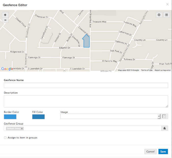
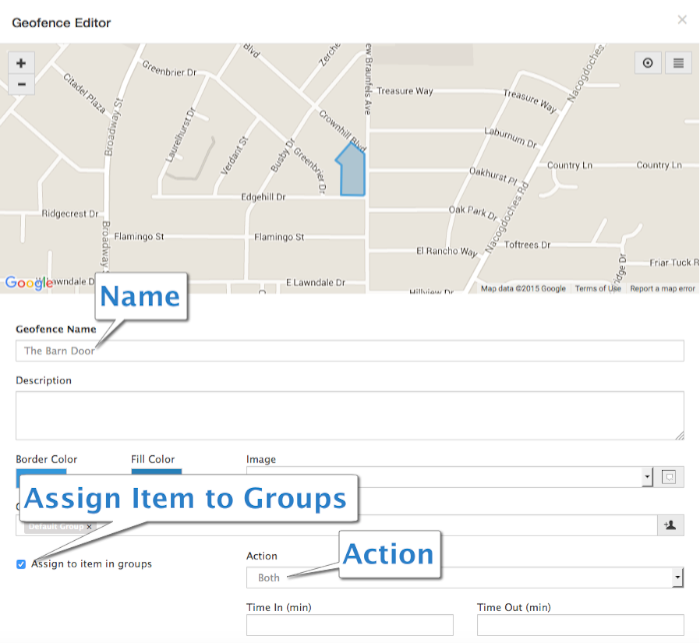
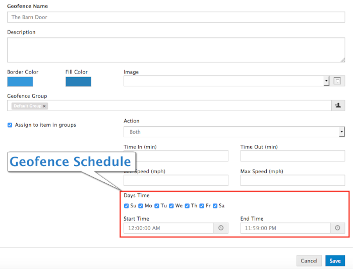
Efficient Fleets is proud to announce that we are now an Omnitracs XRS Authorized Reseller. The Omnitracs XRS platform delivers enterprise-grade fleet solutions to companies of any size. The XRS system is designed to deliver cutting edge solutions in GPS tracking, HOS compliance, and fleet optimization to a smartphone, tablet, or rugged handheld device.

The XRS system is designed with the trucking industry in mind. Efficient Fleets is committed to bringing the best technology to our clients. We consider Omnitracs to be the best in their industry and therefore we are proud to represent them in San Antonio and South Texas.

The XRS platform is a great solutions for fleets of all sizes. There are no upfront hardware or installation costs which makes the system affordable and easy to implement.

We offer a complete set of services for the XRS platform including sales, service, setup, and training. To learn more about the XRS platform please click here.

Please contact us today at 888-777-4510 to request a quote or to setup a free demo.

Michael Goldberg

President, Efficient Fleets

Milo GPS Dashboard Overview

Milo GPS Dashboard

The Milo GPS Dashboard provides insight into the current status of your fleet. It shows important information such as average idle time, top max speeds, and current alerts.

The Dashboard allows you to organize your fleet into groups. Vehicles, assets, and individuals are managed inside groups. You can add new ones and change their attributes, such as name, VIN #, license plate, etc. You can create as many groups as you need.

milo gps dashboard


  1. Add Group: click this button to add a new group.
  2. Alert List: click here to see a complete list of alerts.
  3. Alerts: this section shows a summary of the total number of alerts generated by alert type.
  4. Announcements: shows information posted by the administrator of the account.
  5. Average Idle Time (Min): the Average Idle Time (Min) shows the 5 vehicles with the highest average idle time for the last 24 hours. The info is updated every 5 minutes.
  6. Dashboard: click here to return to the Dashboard.
  7. Geofence: click here to access the geofence page. The Geofence page is where you crete, manage, and assign geofences.
  8. Group: a group is where you organize your items. Click on the group name to see the vehicles, assets, or individuals that belong to the group. Alerts are setup by group. An unlimited number of groups can be created.
  9. Login: shows the user that is currently logged in. Click here to logout and/or change the current user’s password.
  10. Message List: click here to see all the messages sent to and received from a Garmin navigator.
  11. Recent Alerts: this area shows a list of the most recent alerts. Click on an individual alert to see more details.
  12. Reports: click here to access the report section of Milo. There are 22 reports to help you manage your vehicles and assets.
  13. Routing: the Routing page is where you can locate the closest vehicle to an address.
  14. Show Group List: click here to display a list of all the vehicles, assets, or individuals in the system.
  15. Speed Gauge: click here to access your Speed Gauge account. Speed Gauge is a safety system that uses the vehicle’s speed to determine if the vehicle was traveling above the posted speed limit. Please contact Efficient Fleets to setup a Speed Gauge account. Additional fees may apply.
  16. Summary: this section shows the status of the active items in the system.
  17. Tools and Settings: click here to access the Tools and Settings section. This is the administrative area where you can manage general system settings and security, access import tools, plus more.
  18. Top Max Speeds: this section show the 5 vehicles with the highest max speed for the last 24 hours. The information is updated every 5 minutes.
  19. Tracking: click this tab to track your vehicles on a Google Map.
  20. Workflow: click here to access the Milo job scheduling module. Please contact Efficient Fleets to activate Workflow if you do not see the tab. Additional fees may apply.

Car Accident Verified By GPS Tracking

Quickly Locate the Car Accident

A client called me the other day about a car accident. One of his drivers was in a minor fender bender. He wanted to know if his GPS tracking system had any info to help him. He specifically wanted to know if the driver was where the accident happened and how fast he was driving prior to the accident.

Both of these things could easily be done with the GPS tracking. I showed him how to quickly find the location of the accident and then to see if the vehicle was there. Once the client found the location of the vehicle he was able to see the vehicle’s speed before the accident.

This information helped him to quickly determine if the employee was telling the truth. He was able to verify the location and the speed in a just a few minutes.

car accident

Please note that most GPS tracking devices are not black box recorders. In other words, they are not designed to record all of the vehicle’s activity right before and after an event like an accident. Most of them are designed to send information, such as vehicle speed and location every 60 seconds.

GPS tracking can benefit fleets of any size. The ability to know where your vehicles are at any time and where they were is extremely valuable. If you have any questions please contact us at 888-777-4510.

To learn more about our GPS tracking systems please visit www.EfficientFleets.com.

Thanks for reading,

Michael Goldberg

President, Efficient Fleets

Improve Customer Service

Improve Customer Service and Boost Profits

GPS tracking is a great way to improve customer service. It can provide the verification that you need to ensure that you deliver the service that your customer’s expect. One of the most exciting ways that our clients use GPS tracking is to verify that they showed up on time and completed the job. Many of our clients have contracts with their customers that state how many times they have to show up. GPS tracking can automatically provide that verification.

improve service

Yesterday I was speaking to a client who explained that they used to constantly get complaints from their customers that they did not show up. The client is a waste management company that operates west of San Antonio, TX. Good, prompt service is how they have built their business.

No Way To Verify

Before they installed GPS tracking in their trucks all they could do was agree with the customer, apologize, and offer a refund or free service. Once they installed a tracking device on their trucks they could easily verify if they were there or not.

Stop Losing Money

Now when a customer calls to complain they have a quick and easy way to solve the problem. Our client is able to quickly check if the vehicle showed up. They can easily provide their customer with a map and a GPS report that shows what happened.

The result for our client has been in an increase in profits and better service for their customers. If you have any questions or comments please feel free to contact us or email me at mgoldberg@EfficientFleets.com.

Michael Goldberg

President, Efficient Fleets

improve customer service


How To Create A Polygon Geofence – Milo GPS

What Is A Polygon Geofence?

A polygon geofence is a virtual fence that you can draw in the Milo GPS tracking system to monitor when an item (vehicle, piece of equipment, or person) crosses the boundary. Geofences can be used in a variety of situations. For example, when you want to verify when when and for how long your vehicles are visiting a customer. Another good reason is to prevent your drivers from visiting places that are off limits during work hours, such as their home, girlfriend/boyfriend house, etc.

polygon geofence


Creating a geofence is very easy to do. Please follow the steps below to get started.

Create a Polygon Geofence

1. Click on the Geofence tab.

geofence
2. Click on Create.

create geofence


3. Click on Polygon.

select polygon


4. Enter an address into the Address box and then click on the Search button. Include the city and state for a more accurate result.

search address


5. Start drawing the geofence around the result icon by clicking on the map with the left mouse button.
geofence line 1


6. Click again to add another line to the polygon.

geofence line 2
7. When you are finished drawing double click the left mouse button to finish the polygon. Make sure the geofence is large enough to cover the appropriate area.

geofence finished


8. Click Save.

geofence editor


9. Enter a name. Then select Assign To Items In Groups and choose Both from the Action dropdown menu.

geofence editor 2


10. Scroll down the Geofence Editor. If necessary change the days and hours that the geofence is active.

geofence schedule


11. Click Save. The geofence is now ready to start recording when a vehicle enters or exits the boundary.

barn door geofence


Next Step: setup a geofence alert. This step is not mandatory, but if you want to receive and/or record an alert then you need to set one up. Click here to learn how.