Monthly Archives: November 2013

How to Create a Circle Geofence

Geofence
A geofence is a virtual fence. You can setup alerts to warn you when an item enters or exits a geofence. You can create three types of geofences: circle, polygon, or route. A circle or polygon geofence is used to define an area. A route is used to keep an item on a designated path. There are two steps to creating a geofence: drawing and assigning it to an item.
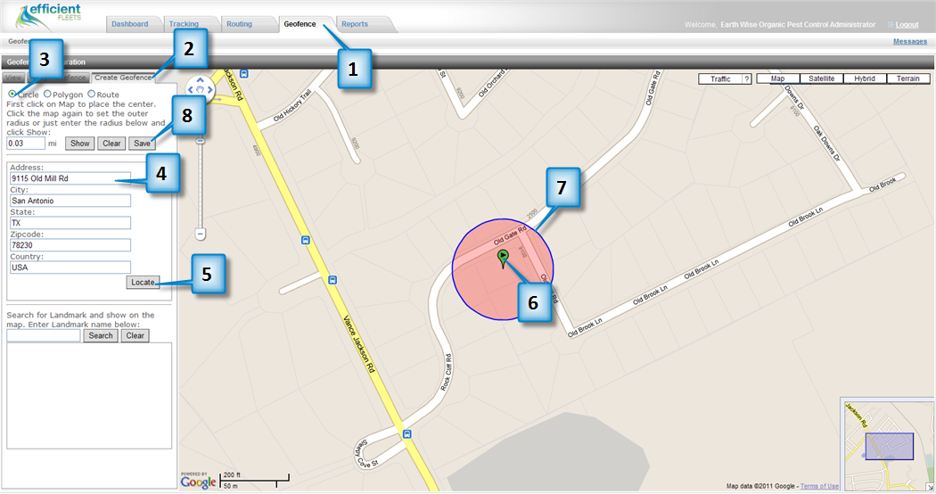
Create a Circle
1. Click on the Geofence tab.
2. Click on Create Geofence.
3. Optional: Click on Circle. By default the Circle should be selected.
4. Enter an address including city, state, and zip.
5. Click Locate. You should now see an icon on the map indicating where the address is located.
6. Click on the icon to create the center of the circle.
7. Click the map again to set the outer radius.
8. Click on the Save button.

Geofence 1

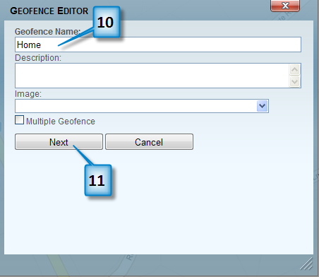
9. You should now see the Geofence Editor box.
10. Enter a name for the geofence.
11. Click on the Next button.
Geofence 2

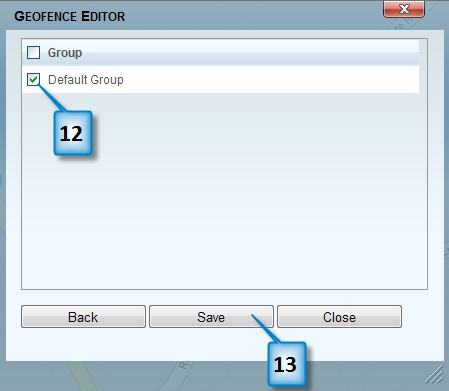
12. Click on the checkbox next to the Group(s) that you want to assign this geofence to.
13. Click on the Save button.
Geofence 3
Tip: You can enter the radius in the mi textbox (next to the Show button) instead of clicking on the map.

Routing

Routing

You can find the closest item or vehicle to an address or landmark by using the Routing page. You can also get directions from a starting address to an end address.

Tracking 1
Routing Page

Find the Closest Item
This tool allows you to find the closest item by using an address or clicking on the map.

1. Click on the Routing tab.
2. Enter an address (including city and state) into the Destination
textbook.
3. Click on Locate.
4. You should now see a list of vehicles that are closest to the
location that you clicked on.
5. Optional: Click on the Direction button to get directions to the
destination from the selected vehicle’s current location.

Destination

Directions

Directions
Tip: Click on Reported within last 24 hours checkbox to only find vehicles that have not reported in the last 24 hours.

Get Directions
Get Directions gives you an optimized route between two locations.

1. Click on Get Directions.
2. Enter a start address or click on somewhere on the map.
3. Enter an end address or click on somewhere on the map.
4. Click the Get Directions button.
5. You should now see a set of directions.

Get Directions

Tracking Page

Tracking Page

The Tracking page is where you can see your items (vehicles, assets, individuals) on a map. The icons indicate the last reported location of each item. You can search for old routes, check the status (ignition on/off, idling, or moving) of an item, view alerts, plus much more.

You can click on the icon to view information about that item, such as current location, speed, date/time, and daily mileage. The map will automatically refresh every 2 minutes to display the most current location. The refresh rate can be changed if necessary.

Tracking 1

Tracking Page

Item

Name

Description

1

Item Icon

Last known location of an item (vehicle, asset, or individual). The icon will change depending on the status of the item. There are three statuses: stopped, moving, and idling.

2

History

History tab is where you can search for and playback old routes.

3

Filters

Filter out vehicles to display on the map by status.

4

Item Name

Name of the item.

5

Last

Last time item reported in.

6

Information

Click on this icon to see detailed information about the current trip and the item.

7

Status

Current status of item.

8

Alerts

Indicates if there is a current alert for the item.

9

Messages

Send messages to the GPS device. Not all GPS devices can do this. If you are not sure about your device please contact Efficient Fleets.

10

Ping

Ping GPS device to get current location of unit.

11

All Group

Filter out items by Group.

12

Search

Search by item, item description, item’s driver name, or vehicle tag.

 13

POIs

Display all the active landmarks on the map.

14

Geofences

Display all the active geofences on the map.

15

Map Lock

Activate map lock to center the map around an item as the map refreshes.

16

Print

Print the map with the items and summary of daily activity.

17

Measure

Measure distances on the map.

18

Set View as Default

Make the current map view the default view.

19

Export to KML

Export the current location of all the items to a Google KML file for use in Google Earth.

20

Set Refresh

Set the refresh rate for the map. By default the map refreshes every 2 minutes.

21

Refresh Time

Amount of time left before map refreshes,

22

Expand Map

Click the arrow to expand the map to the entire width of the web browser.

23

Location Bar

Display the Location Bar which shows information about the current location of the item, such as address, latitude, longitude, and date and time.


Landmark Status

Landmark Status

A landmark status is an attribute that can used to describe the condition of a landmark. For example, if you have fueling sites as landmarks you could set their status to “active” to indicate they are working. It is not necessary to create a status in order to use landmarks.

Create Status
1. Go to Tools and Settings.
2. Click on Create Landmark Types and Status.
3. Click on Landmark Status.
4. Select the Landmark Type that you want to associate with the status.
5. Click on Add New Status. You should now see the Landmark Status Editor.
6. Choose an image.
7. Enter a Status Name.
8. Click on the Save button.

Landmark Status 1


Landmark Type

Landmark Type

A landmark type is an attribute that you can add to a landmark to help organize your points-of-interest (POI). For example, a “customer” type would indicate that a POI is a customer. The type can be set when creating or editing a landmark. You can update a type in the landmark detail page.

Create Type

1. Click on the Tools/Settings tab.
2. Click on the Tools and Settings link.
Landmark Type 1
3. Click on Create Landmark Types and Status.
Landmark Type 2

4. Click on Add New Type. You should now see the Landmark Type Editor dialog box.
5. Choose an image.
6. Enter a name.
7. Click on the Save button.

Landmark Type 3

How to Setup Landmark Visits

Landmark Visits

The Fleet Management System can record every time a vehicle visits a landmark. The system records the date and time of every arrival and departure. You can run the Landmark Entry/Exit report to see the data. Follow the steps below to setup landmark visits.

1. Click on the Pencil next to the landmark that you want to edit.
2.  Click on the Additional Settings tab.
3.  Enter a buffer size into the Landmark Buffer (mi) textbox. See Importance of Buffer Size below for more details.
4.   Optional: change the Buffer Alert if you want to know when an item leaves a landmark. By default it is set to In, which tracks when a vehicle arrives at a landmark.
5.   Optional: click on the Generate Alerts? checkbox if you want to setup an alert whenever a vehicle enters or exits a landmark.
6.   Click on the Save button.

Landmark Setup 1

Importance of Buffer Size

The buffer size helps determine when a vehicle has visited a landmark. If the buffer size is set to .25 then every GPS location within ÂĽ of a mile of the POI will be considered to have visited that landmark. In general a smaller buffer is preferred because there will be less chance to catch locations that did not truly visit the landmark. For example, if a landmark represents a store located inside a shopping center and the buffer size is too big then a vehicle that was at stopped at the intersection would be considered visiting the landmark.

Efficient Fleets Welcomes Cleer Transportation!

Welcome Cleer Transportation to the Efficient Fleets’ Family

We are proud to announce that Cleer Transportation of San Antonio, Texas is part of the Efficient Fleets family. Cleer Transportation is a non-emergency transport company that safely transports patients from their home to a doctor’s visit, clinic, or hospital. A typical day starts around 4:00 AM for most of their drivers and can easily last 12 hours. Their day is spent picking up and dropping off patients. As one patient is dropped off another one has to be picked up. Dozens of patients are transported every day. This can put tremendous pressure on the dispatcher and the driver to be on time and safe. With a fleet of over 10 vehicles this was becoming very difficult to manage.

How Does Efficient Fleets Help

Cleer was looking for a cost effective and easy-to-use solution which they found with Efficient Fleets. Our fleet management and GPS tracking solutions have provided great benefits, such as a safer fleet, better productivity, and improved customer service. They are now able to dispatch more effectively and control fuel costs. With the click of a mouse they know the current location and speed of every vehicle. They can also determine exactly when a van arrives and leaves from any location.

Please contact us if you have any questions about how we have helped Cleer Transportation become more successful. Our mission is to deliver the most innovative fleet management solutions based on GPS, wireless communication, and easy-to-use software.

Happy Holidays!

Michael Goldberg

How to Edit Landmark Location

You can easily edit the location of a landmark if it is not in the right location.
1. Click on the next to the landmark that you want to edit.
2. You should now see the Landmark Detail page.
3. Navigate on the map to the new location (hold down the left mouse button over the map and drag the map in the direction that you want to go).
4. Double click on the map to indicate the new location.
5. Click on the Map Location button.
6. You should now see the icon in the new location.
7. Click on the Save button.


Tip: Alternatively you can enter a new address and then click on the Map Location button.

How to Create Landmark or Point-of-Interest

A landmark is a point-of-interest (POI) that can be displayed on the map. They are useful when your vehicles visit the same locations on a frequent basis and you want to know when they arrived and how long they were there.

1. From the Dashboard, click on a group to enter the Group Editor.
2. Click on the Landmark tab.
3. Click on Add New.
Landmark 1

4. You should now see the Landmark Detail page.
5. Enter a Landmark Name.
6. Enter an address, city, state, and zip code (optional).
7. Click on the Map Location button. You should now see the location of the landmark.
8. Click on the Save button.

Landmark 2


Improve Billing To Boost Profits With GPS Tracking

Boost Profits Improve BillingProfit margins can be thin for private ambulance or transport companies. There are numerous costs, including fuel, labor, and vehicle maintenance. However, there is one cost that is hidden, billing errors. Maintaining accurate records is difficult to do. Incorrect and inefficient billing can cost a company thousands of dollars. Many people know that GPS tracking can be used to lower fuel costs. However, few know that it can also help improve billing by increasing accuracy and automating routine tasks.

The traditional methods of ensuring accuracy are time consuming and tedious. They often include paper logs and cell phones or radios. The driver usually records the arrival and departure times and the corresponding odometer in a log book. Sometimes the driver has to call the dispatcher to report his or her information.

There are several problems with this type of solution. The first one is accuracy. The driver and/or the dispatcher may record incorrect information. Once this happens there is very little that can be done to correct it. If a patient calls to complain there is no way to verify who is right. The second problem is the time it takes to record, compile, and store the information. These tasks take valuable time that could be used for something more productive.

How Does GPS Tracking Improve Billing

[list style=”correct”]

  • Automatically Record Exact Arrival and Departure Times
  • Report Total Stop Time At Each Location
  • Automatically Calculate Vehicle Mileage

[/list]
The GPS receiver automatically records the date and time of  every stop. The arrival and departure times are used to calculate the total stop time for each location. This information is useful in many ways. For example, it can be used to determine which drivers are more efficient by comparing stop times. It can also be used to improve customer support. If there is a dispute with a patient this information can be easily retrieved and used.

A GPS tracking system automatically calculates mileage by day, trip, and between stops. This can help determine the cost of each trip. The cost can be calculated by using an average MPG times the miles per trip. A more accurate cost will help ensure that the company is charging correctly for its services.